A second report from Utah’s canyon lands
Posted on July 6, 2013
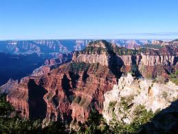
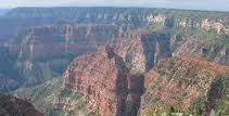
The South Utah canyon lands are incredibly dramatic and just when you think you’ve seen the most extraordinary place, you discover another. We spent the 4th of July at the North Rim of the Grand Canyon, a gaping hole (yes, pun intended) in our travel experiences. Again, a site not at all oversold. The North Rim sees only 10% of the visitors of the more accessible South Rim and sits 1000′ higher. Most GC experts content that the views are more dramatic. We have no basis for comparison, but it is hard to imagine anything more dramatic.
However, before we arrived, we drove 2.5 hours through multiple eco-systems including Sonoran desert, arid and scrubby with actual tumbleweeds blowing across a highway. We then started to drive up and out of the desert into the Kaibab National Forest, a sub-alpine area that tops out at 9200′ and that is filled with evergreens and broad alpine meadows and that finally leads to the North Rim. As we approached we got glimpses through the trees, but it is when you park at the Lodge and walk out onto its observation deck that you hear everyone’s sharp intake of breath. It is as dramatic a landscape as we have ever seen.
We walked along the rim trail and stepped out onto the observation points and it was hard not to have vertigo. The canyon walls plunge down a mile and even though the paths are wide, we found ourselves leaning away from the edge and often running a hand along whatever rock wall presented itself. VT has Queechee Gorge. It’s a pothole in comparison. A divit. The Grand Canyon is…well, grand. Damn grand. It is “Holy Sh*t, do you believe this?” grand.
And yet you see people climb out to rock outcroppings and pose for pictures, just a slip or step away from their certain demise. And it happens. A lot. Three people this week alone and one at the North Rim the day we were there (though we missed it, thank God). There is something about the canyon that is existentially disturbing and beautiful all at once and I was reminded of that chapter in Moby Dick when Pip goes overboard and realizes the absurdity and wonder of his place in an infinite universe. We all confessed to having “falling off cliff” dreams the night after our visit.
Apparently, people not only fall off (candidates for the Darwin Awards in most cases), but are pushed off and jump off willingly. Add to that lightening strikes, rock falls, drowning in rafting accidents down in the Canyon, and the whole place reminded me of my theory developed while visiting Montana: that the West has more ways to kill a person than you can imagine. I’m not sure the West likes us.
Leaving the lodge area, we drove out to Imperial Point, a place where it feels like the end of the earth, and gazed again at the stunning grandeur of the Canyon.
We have all traveled quite a bit and to exotic places in the world, but we all agreed that we had not seen anything quite like this.
We had lunch at the disappointing Grand Canyon Lodge, a place of uninspired food, stained carpeting, and deflated staff (though seeing the general state of humanity while there, I sort of felt their pain). But the lodge perches on the edge of the canyon and the views more than made up for the general sorry state of the place.
By the way, the discerning reader will note that the 9000′ elevation of the North Rim is 3000′ higher than Zion, though in explaining the Grand Staircase in an earlier post I said the top of the Grand Canyon formed the floor of Zion. We were puzzled and asked yet another helpful Park Ranger. He said we were right, but that a geological upshift lifted the area north of the canyon some 25 million years ago (really these numbers are so big as to be rendered meaningless except in relationship to each other). So geologically, the top of the canyon forms the bottom of Zion, which they can tell by the various strata of rocks, but that in terms of altitude, the North Rim is higher. He went back into the office and dug out a chart, then walked us over to a model, and patiently explained the various theories about how the canyon was then actually cut (because the then younger Colorado River was only 6 million years old and should have simply run down hill to lower elevations, water seeking the easiest path). These guys are so cool and nerdy all at once — we love ’em. And, secretly, we could tell he was relieved to finally have a question that required some intelligence instead of the “Why do you all wear those Smokey the Bear hats?” questions we were overhearing.
If you haven’t been, get in your car and drive west and go see the Grand Canyon. I’m a little ashamed it has taken me 55 years to get there and now I want to take 12 days or so to raft the thing from end to end. It is one of the great sights on the planet.
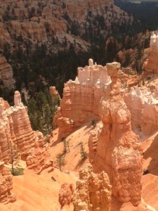
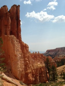
Just when we thought we couldn’t be surprised anymore, we the next day drove to Bryce Canyon. Technically an ampitheater and not a canyon, Bryce looks like the landscape of another planet. Like something out of Star Wars.
By the way, how cool is the “panoramic” option in the iPhone 5 here? Bryce is famous for its hoodoos, tall strange limestone towers.
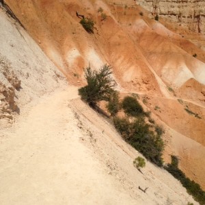
Rainwater eroded limestone, hoodoos start as arches or windows and then the middle section erodes away and falls, leaving the towers on both sides. Other features include multicolor cliff side walls that look like dripped candle wax, and windows (openings through thin fins of rock), and high hilly desert floors with juniper trees and pinon pines improbably clinging to the cliff sides. With every turn in the trail or top of a ridge we were blown away.
We did what the The Hoodoo (the parks’ newspaper) calls its “ultimate hike” and by the end, we knew why they call it so. We descended into the canyon from the rim at 8001′ and dropped 1631′. Remember that whatever goes down has to come back up again. We did the “Figure 8”, a 6.4 mile combination of three trails that was almost never flat. We went up and down and back up again and down again. At 8000′ we get about 70% of the oxygen that we usually get and it takes a toll. As the rangers advised, it takes about twice as much energy on the ascents. The recent heatwave had broken by TH and we mostly hiked in 70 and 80 degree temps, but it was hard labor and we went through every bottle of water and Gatorade I was lugging in my backpack.
But the reward for the hike was stunning scenary and very few people on the trail. There were times when we stopped and just stood in silence in an absolute quiet we rarely get anymore in modern life.
Of course, it could have been that we had no extra breath to spare on actual talking. The other thing about Bryce was that despite the heights, the trails were wide and there were few plunging cliff sides. Bryce didn’t have the lurking malevolence of the Grand Canyon.
The trail did become unshaded and hotter as we approached midday and we were conscious of the thunderstorms that were predicted for afternoon. Amazingly, we ran into people just starting their hike despite the low rumblings of distant thunder and darkening skies.
Moreover, any number of them were wearing flip flops and carrying maybe one bottle of water. It must drive the Rangers crazy. They have taken to posting pictures and stories of super fit people, like marathon runners, who have died from dehydration and underestimating the impact of altitude.
We felt that last factor on the ascent out of the canyon, spurred on by the sound of thunder closing in. Switchback after switchback, the climb out is steep and strenuous. The equivalent of walking up 160 flights of stairs at an altitude 3000′ higher than Denver, the Mile-High City. We had to stop frequently to catch our breath and by the end we looked like we were in one of those French Foreign Legion movies, hot and dusty and just putting one weary foot in front of another.
The Forest Service has a “I Hiked the Hoodoos” program in which one finds the distance markers along various trails and takes a picture with them to get a reward. We did all three on our trail
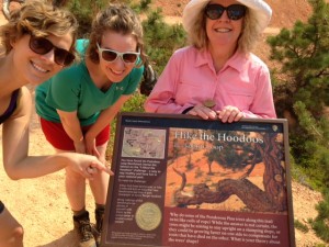
and showed the Ranger back at the Information Center and each received our “I Hiked the Hoodoos” pin and we gripped them like we were winning Olympic gold. We earned those babies!
We also earned a great lunch at the nearby Bryce Pines Restaurant. A cold beer (Utah has some great beers, by the way) and sandwich never tasted so good and Shauna, our welcoming waitress decked out in cowboy garb, insisted we try their home baked pies and how could we say no. We lingered as the skies opened up in torrential sheets of rain and booming thunder and rubbed sore quads and calves.
It was a totally satisfying experience from start to end. There was something about these last two days, about spending the 4th of July in such a quintessetially American place, that felt just riight. We have been running into people from all around the globe that have come to marvel at this big, open, dramatic country. If I lived here, I’d own a gun (still supporting sensible gun laws, mind you), drive a pickup or a big old SUV, wonder about why we need big government, and probably not even give a damn about saving any whales. If those whales can’t save themselves, why hell…they deserve it. This is a place that seems self-reliant and tough and neighborly and it feels like America. At least America of our national myth and like all myths, it speaks to some essential truths. But more than anything, it speaks to the immensity of the place and the notion that a person should have the space to be free. It makes you wonder, if for just a minute, why anyone lives in cities.
And then it tries to kill you in some other way (as when someone in Bryce warned us about a rattlesnake ahead) and you remember that it is easy to romantacize a place and my NY Sunday Times is probably not waiting for me at the Mt. Carmel Trading Post tomorrow. But if there was ever a place to romantacize, to stir the heart and soul, to evoke Nature with a capital “N,” it is this place.
